
Trace a Midwest City Street Address
Use a single, exact address to begin a street-by-street search. Midwest City sits in Oklahoma County, but its municipal edge meets Oklahoma City, Del City, Spencer, Nicoma Park, and Choctaw. That makes the exact situs address, the physical parcel location used for assessment, more reliable than a postal place name alone. A current owner line or tax mailing address can be useful context, yet neither confirms that a person lives at the property. Keep the source, date, and relationship beside every finding.
- Validate the street number, direction, and suffix. Check the current city limit before treating an address as a Midwest City municipal record.
- Run the physical address through the Oklahoma County Assessor. Save the account, Parcel PIN, situs, and legal description instead of only the owner line.
- Open the county parcel viewer to see road frontage, adjoining parcels, and whether a nearby feature is a parcel, right-of-way, or common area.
- Use the legal description or PIN to narrow the County Clerk record trail. Record document and recording dates separately.
- Use voter verification only for a named person where the official portal requires its fields. For dated household context, use an archive or library route rather than assuming a current record reaches backward.
The sequence is address, parcel record, map context, recorded document, then dated supporting evidence. It is a repeatable Midwest City street directory method, not a promise that one result identifies every person connected to an address.
Midwest City Street Assessor Fields
The Oklahoma County Assessor search is the most direct starting point for a physical Midwest City address. It accepts owner name, physical address, real, personal, or central account, subdivision/block/lot, map number, deed book/page, and occupant or building name. An address search normally needs its direction. The official examples use percent signs for partial searches, such as 4% W Main or 3% W Reno, while suffixes are optional. Parcel records represented only by legal description may not appear through a plain address query.
| Assessor field | Best use on a street | Format or limit |
|---|---|---|
| Physical address | Find one situs or a partial street segment | Direction is required; % can stand for part of an address |
| Owner name | Reconnect a tax-account party to a known parcel | Last name first, without punctuation or hyphens; last-name-only may use a wildcard |
| Real, personal, central account | Return to a known assessment account | R plus 9 digits, P plus 7 digits, or C plus 7 to 10 digits; no wildcard |
| Subdivision, block, lot | Match a plat-based legal description | Useful when a street result is broad |
| Map number or deed book/page | Cross-check map or recorded-document clues | Use the displayed record labels when carrying the search onward |
The Assessor address-search screen shows the portal used to start the parcel trail.
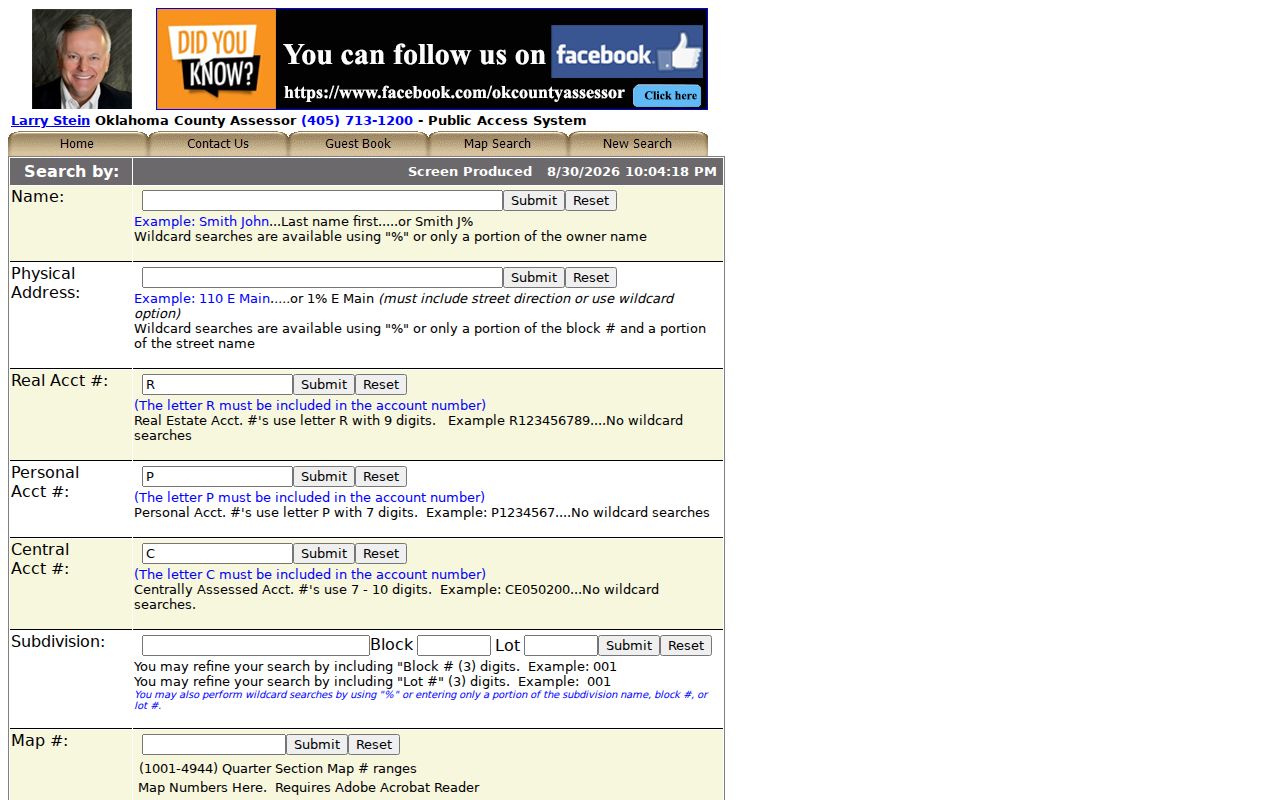
A result can display account and property type, situs, owner, PIN, mailing and billing details, tax district, school system, acreage, value, legal description, and sales or deed history. Those fields establish parcel context. Values can change, and the county says the map is not a legal survey.
Midwest City Street Boundary Check
A postal city and a municipal city are not the same thing. Before using a city permit, code, or clerk route, compare the situs to the Midwest City city-limits service. Its REST query endpoint supports location and geometry queries, spatial relationships, returned fields, pagination, and statistics. That makes it a current boundary tool, not a historical annexation archive or proof of a parcel line.
Next, use the Oklahoma County parcel viewer for parcel shape, roads, and nearby geography. It helps distinguish a neighboring lot from an alley, drainage tract, school, utility feature, or common area. A map view is spatial context only. The definitive legal description remains in the recorded County Clerk deed, and no official source in the research set established a complete historical annexation or street-renumbering chronology for Midwest City.
Boundary check first. At the east-metro edge, the same corridor can touch more than one municipality. A Midwest City street search needs a current city-limit check before municipal records are treated as relevant.
Midwest City Street Record Coverage
Address-keyed records do not form a single resident roll. The useful question is what each custodian actually records. The assessor ties a tax account to a parcel. The GIS viewer maps it. The County Clerk preserves land instruments. City systems may document an application, an address-based complaint, or municipal activity, subject to their own release rules. The Oklahoma Voter Portal verifies an individual registration status after the required name and date-of-birth inputs, but it is not a street roster.
| Midwest City street source | What it can show | Access path and limit |
|---|---|---|
| County Assessor | Situs, owner tax-account relationship, Parcel PIN, mailing or billing address, legal description, value, and sales/deed history | Free search; owner or mail recipient is not confirmed occupancy |
| County GIS | Parcel geometry, roads, adjoining parcels, and jurisdiction context | Free viewer; not a legal survey |
| County Clerk ROD | Grantor, grantee, document type, recording date, legal description, book/page, instrument, or PID | Online index; images can lag recording and some records may need an office or request route |
| Midwest City permits | Cityworks application, attachment, review status, and parent-child workflow context | Portal availability does not establish which public fields or inspection details are released |
| Oklahoma Voter Portal | Registration status, polling place, and districts for an individual verification | Requires first name, last name, date of birth, and a verification flow; not proof of occupancy |
The parcel PIN and legal description provide the cleanest bridge between address formats. Copy both exactly, then compare the county record with a current map and, if needed, the deed index. This Midwest City street directory approach avoids turning a mailing address, recorded party, or voter status into a claim about who is present at a home.
Midwest City Street Site Records
Municipal records can add context to an address without creating a household list. The Midwest City Permits and Inspections route leads to Cityworks, where applications, attachments, review status, and parent-child links are part of the stated workflow. It is appropriate to confirm the current public view before relying on a specific field. The research did not establish that names or inspection history are publicly available for every address.
The Code Enforcement route asks for a location and the nature of a possible violation. A code entry may concern a site rather than a person, and publication or redaction practices were not established in the source material. City records can also relate to a street through meetings, improvement work, contracts, or municipal services. Label each item by its actual role, such as applicant, complainant, or incident location, rather than treating it as a residence record.
When an online result is missing, use a narrow request to the right custodian with the address, record type, date span, and desired format. Oklahoma County land records belong with the County Clerk, while Midwest City municipal material belongs with the relevant city office. A precise request is easier for an office to evaluate than a request for everyone associated with a street.
Midwest City Street Deed Trail
After the assessor supplies a PIN or legal description, search OKCC Online only as far as the street question needs to go. The Recorder of Deeds side offers name, address, document type, book/page, instrument or PID, and advanced paths, plus plat, e-file, forms, and property-alert tools. Search the legal description when an address changes form or when a subdivision, block, and lot make a more exact match than a street number.
Recorded documents can connect grantors, grantees, trusts, estates, lenders, releases, easements, and legal descriptions. They do not automatically establish a move date or a current resident. Online images are unofficial, redacted, and free where available; official or certified copies have fees. The Clerk cautions that recently recorded documents can take time to appear online, and some document types may not be online at all.
Keep the instrument date, recording date, document type, legal description, parties, book/page or instrument number, and image status in separate notes. If the Clerk record is incomplete, call the office at 320 Robert S. Kerr Ave. in Oklahoma City or use its request route. The Assessor office is at 320 Robert S. Kerr Ave., Suite 313, with public hours Monday through Friday, 8:30 a.m. to 4:45 p.m., and phone 405-713-1200.
Midwest City Street Address Roles
One address can appear in several forms across a Midwest City street directory search. The assessor separates the situs from billing and mailing addresses. A billing recipient may be an owner, lender, management company, former owner, or an address outside Oklahoma. A homestead or owner-occupied exemption is a tax classification, not a guaranteed statement about present occupancy. The owner line is therefore best labeled as an owner tax-account relationship as of the record date.
The Oklahoma Voter Portal can verify registration status, polling place, and districts after its individual lookup fields are supplied. It does not establish that a named person currently occupies a property, and it does not maintain phone, race, gender, or ethnic-origin fields in voter records. Public record work is strongest when two independent sources support a limited conclusion and each source is described by its actual purpose.
Midwest City Street Record Terms
Street searches often shift from a familiar house number to county land terms. These labels preserve the difference between a physical place, a mapped parcel, and a recorded description. They also make a later search easier when an older document uses a subdivision or land description instead of a modern street address.
- Parcel
- A defined tract in the assessment and map system, usually identified by an account or PIN.
- Situs address
- The physical location used by the assessor for the parcel, distinct from the address used for tax mail.
- Plat
- A recorded map that lays out a subdivision or addition, often helping connect a block and lot to a street.
- Criss-cross directory
- An address-first directory format that can offer dated context for a block. No direct online Midwest City directory run was located in the OHS City/Year search.
For older household questions, use a library or archival collection as corroboration and retain the publication date. A directory entry, newspaper item, or yearbook mention supplies a dated lead, not an unrestricted current-address certification.
Midwest City Postal-City Check
The postal-city paradox is a useful Midwest City street research check. The Midwest City Post Office at 8275 E Reno is displayed by USPS as Oklahoma City, OK 73110-9998. That display does not change the physical city limit, and the five-digit ZIP does not define a neighborhood. Tinker Air Force Base also has its own 73145-9998 postal context. Postal routing, county parcel jurisdiction, and municipal limits must be tested separately.
Use the USPS ZIP Code Lookup to validate the exact mailing address, then use the Midwest City limit layer for the municipal question and the county parcel records for land context. This order matters around I-40, US 62, Sooner Road, Tinker Diagonal, E Reno, and other east-metro corridors. USPS confirms postal formatting, not legal jurisdiction.
Midwest City Street Evidence Notes
A concise evidence log prevents a street search from becoming a list of unsupported names. Start with the current address as entered, then save the normalized situs, city-limit check date, assessor account and PIN, legal description, source link, and access date. For a map result, record the viewer extent and whether the adjacent feature is a parcel, right-of-way, common area, drainage tract, school, utility, or business.
| Record note | Why it matters |
|---|---|
| Street number, direction, suffix, unit or lot | Reduces false matches caused by abbreviated or partial address formats |
| Assessor account, PIN, and legal description | Reconnects the same parcel across the map and recorded land documents |
| Situs, mailing, and owner labels | Keeps a physical location separate from tax-mail and ownership roles |
| Document and recording date | Prevents a later recording from being mistaken for a move date |
| Source and access date | Shows which live record was checked and when it was available |
Note: A no-result screen is not proof that an address, person, or document has no record. It may reflect formatting, timing, jurisdiction, or a record that needs a different access route.
Midwest City Street Directory Limits
No official Midwest City source is a complete list of people who live along a street. Assessor and Clerk records describe parcel and recorded-document relationships. GIS describes geography. Permit, code, police, and association material has its own access rules and may be redacted or unavailable. An individual voter result is a registration verification, not occupancy proof. A protected address can be absent by design.
Oklahoma's Address Confidentiality Program provides substitute addresses for qualifying victims. Do not try to uncover a protected location by combining parcel, voter, deed, or association material. Keep public research narrow, link back to the custodian, and avoid collecting sensitive details that the source does not need to answer a lawful question.
Lawful use. Midwest City street records can support family history, estate research, property curiosity, and civic questions. Do not use any address or record trail to stalk, harass, intimidate, discriminate against, or harm a person.